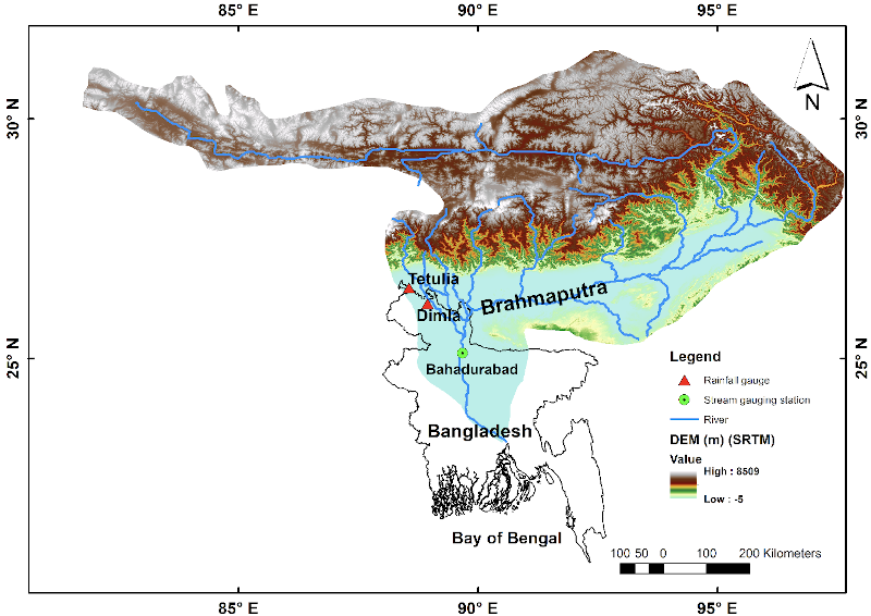
The impacts of the 2020 monsoon floods in Bangladesh were devastating with more than 5 million people affected by the floods, 41 casualties and tens of thousands of people living in low lying areas were evacuated to flood shelters along with their cattle (MoDMR, 2020) (Figure 1). Agriculture is one of the most severely affected sectors due to floods in Bangladesh and according to the Ministry of Agriculture of Bangladesh, 0.15 million hectares crop lands were damaged by the two successive floods waves during the 2020 monsoon (MoA, 2020).
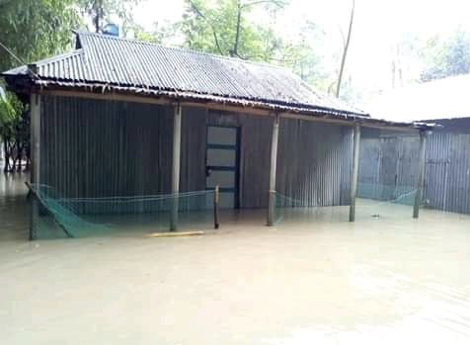
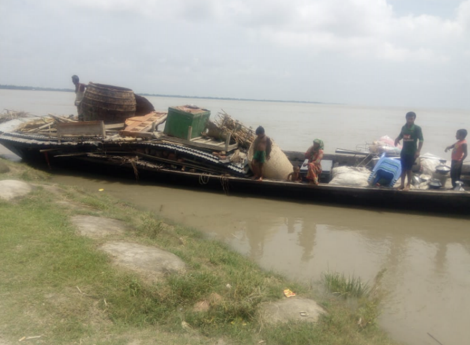
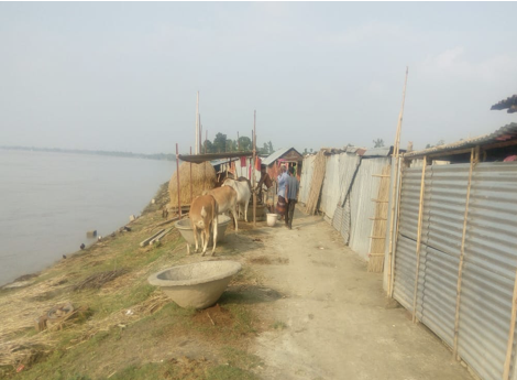
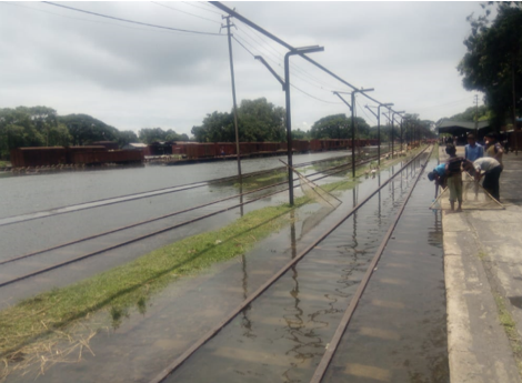
During the South Asian summer monsoon, floods are a frequent natural hazard in the Brahmaputra river basin (Figure 2) in Bangladesh, but the type of flood that happens can vary significantly depending on the monsoon rainfall and basin hydrological characteristics. Flood forecasters consider three very important questions: when will flooding commence during the monsoon period, how long it will last and will there only be one flood or many flood waves? Predicting flood timing and duration with a sufficient lead-time is an additional challenge.
The Global Flood Awareness System (GloFAS) is produced by ECMWF as part of the Copernicus Emergency Management Service (CEMS) and provides operational extended range ensemble flood forecasts with a 30 day lead-time for major world river basins including the Brahmaputra in Bangladesh (Alfieri et al., 2013). The GloFAS team from the University of Reading and ECMWF are working together with the Bangladesh Flood Forecasting and Warning Centre (FFWC) and humanitarian partners to improve flood early warning in Bangladesh under the UKRI/FCDO Science for Humanitarian Emergencies and Resilience (SHEAR) research program, so that forecasts issued to government and stakeholders are as skilful and useful as possible. GloFAS is freely available through a dedicated web interface (https://www.globalfloods.eu) or via the Copernicus Climate Data Store (https://cds.climate.copernicus.eu/cdsapp#!/dataset/cems-glofas-forecast?tab=overview).
GloFAS aims to provide early warning information of upcoming floods with a long lead time to support disaster managers or national institutes for flood preparedness and response actions (Emerton et al., 2016). Here, we consider how GloFAS was used in anticipating floods timing and duration for taking early action to save lives and livelihoods in Bangladesh in the 2020 floods in the Brahmaputra basin.
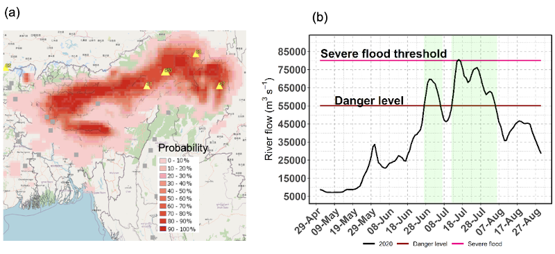
Following cyclone Amphan in May 2020, the Brahmaputra river basin experienced heavy rainfall between 20 to 30 May, before the ‘climatological’ start of the monsoon season in June. This rainfall event was captured by the ECMWF ensemble rainfall forecast with almost 100% probability of exceeding 300 mm of accumulated rainfall over 10 days period (Fig. 3a), which is one of the products available through the GloFAS-CEMS website. This unusual May rainfall event increased river flow before the start of the monsoon, with further increasing as the monsoon progressed monsoon progressed over the basin from middle of June over the basin (Fig. 3b).
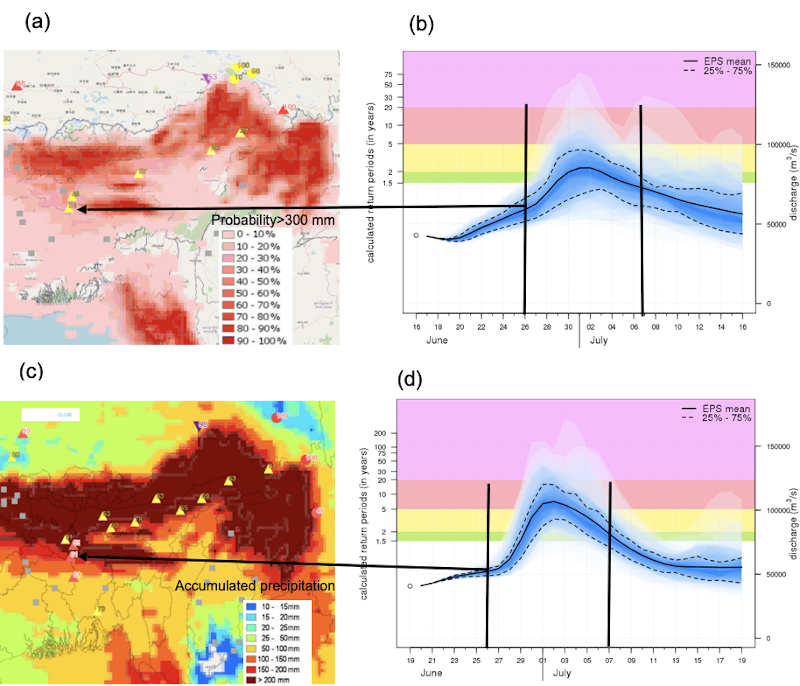
The 16 June 2020 the GloFAS extended range forecasts showed a flood event of ~10 days duration starting at the end of June (Fig. 4b), combined with a strong signal of heavy precipitation further upstream (Fig. 4a). On 19 June, GloFAS signal was even stronger, predicting a flood event exceeding the severe level of 20-year return period floods to start on 26 June and peaking on 30 June (Fig. 4d), associated with a heavy rain predicted for the next 10 days by ECMWF rainfall forecast ensemble (Fig. 4c). Raingauges records also show heavy rainfall between 19 to 26 June (288 mm at Tetulia and 295 mm at Dimla, data source: Bangladesh Meteorological Department, location in Figure 1), which was correctly predicted by the ECMWF forecast. As forecasted by GloFAS 14 days ahead, the first flood wave on the Brahmaputra was observed between the 26 June and 7 July, with flood levels peaking on 30 June.
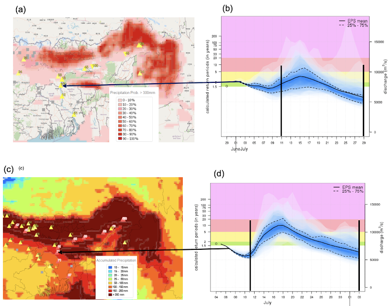
The 29 June 2020 GloFAS forecasted a second flood wave (severity of 2 to 5 year return period level) beginning on 11 July and reaching flood peak on 16 July (Figure 5a and b). This flood also occurred as predicted with the river crossing its danger level on 11 July and floods continuing until the 7 August 2020, with observed peak recorded the 16 July (Figure 5 c and d). Overall, the two flood waves of the 2020 monsoon in the Brahmaputra basin in Bangladesh lasted 35 days, the duration and timing of which GloFAS extended range forecasts were able to predict both the start and duration of these flood events with relatively high confidence and at least a 10 day lead-time. GloFAS predicted flood severity levels were also consistent with the operational flood response activities in Bangladesh. In particular, GloFAS 10-day lead-time forecasts predicted a flood magnitude exceeding the ‘severe flood’ (i.e. similar to GloFAS thresholds 2 year and above return period, through personal communication with Dr Ahmadul Hassan, FbF, Bangladesh) category used for Forecast Based Financing (FbF) by humanitarian agencies in Bangladesh (Fig.6).
Whilst the river flow, estimated (using rating curve) based on observed river levels (Fig. 3b), was clearly lower than the flow values predicted by the GloFAS forecasts (Fig. 6, Fig. 4 and 5), it is important to note that there is always large uncertainty in flow measurements for large rivers during the monsoon, and also the fact that GloFAS provides flood predictions only in the context of its own climatological thresholds. This means that even though the absolute river levels in GloFAS can potentially be far from the observed levels, the probability for exceeding the GloFAS flood thresholds is expected to account for this and show a realistic flood signal (Alfieri et al, 2013).
To anticipate upcoming flooding events, the Flood Forecasting and Warning Centre (FFWC) in Bangladesh now routinely analyses information available from GloFAS on potential flood timing and duration following a successful pilot in 2017 floods. For the 2020 monsoon floods, GloFAS forecast was communicated to different stakeholders from national to sub-national levels, with national news media broadcasting the risk of potential flooding in advance to warn people by the FFWC Bangladesh. National and international NGOs, humanitarian agencies and development partners working in disaster response such as relief distribution have developed Forecast-based Financing (FbF) methods to help their decision making ahead of flood events, including three UN agencies: Food and Agriculture Organization (FAO), the United Nations World Food Programme (WFP) and the United Nations Population Fund (UNFPA), who are implementing FbF in the northern flood vulnerable region of Bangladesh, supported by the Bangladesh Red Crescent Society (BDRCS) and the International Federation of Red Cross and Red Crescent (IFRC).
Based on GloFAS forecasts, the FbF program was set to a pre-activation mode on 4 July, 10 days ahead of the predicted flood of mid-July with a high probability. This triggered a cash distribution to vulnerable communities in the Bogura, Gaibandha, Kurigram, Jamalpur and Sirajganj districts on the 11 July (https://reliefweb.int and through personal communication with Dr Ahmadul Hassan, FbF Bangladesh). The second flood wave continued up to 7 August 2020 and afterwards flows receded to normal in the basin in Bangladesh. This period is usually a challenge for flood forecasters of the region, as with August being commonly the peak of the monsoon season, a new flood wave can be possible. With GloFAS extended range forecasts on the 8 August 2020 showing no remarkable flood signal for August, the FFWC issued an outlook mentioning that no further major floods likely in August in the current monsoon (published in the daily Jugnator on 9 August 2020). Such extended range forecast is critical for agriculture planning. Following the announcement of no further remarkable floods being forecasted for the remainder of the season, farmers in Kurigram and Jamalpur districts started to broadcast “Aman” rice or prepare their seed beds from second week of August to grow seedlings i.e. young plants for transplantation (Figure. 7) (through personal communication with the local flood volunteers), in preparation for the next growing season. Therefore, this anticipatory action can empower communities to protect their lives and livelihoods by taking appropriate flood preparedness decisions for upcoming floods.

GloFAS flood forecast available from https://www.globalfloods.eu/glofas-forecasting/
Alfieri, L., Burek, P., Dutra, E., Krzeminski, B., Muraro, D., Thielen, J., and Pappenberger, F.: GloFAS – global ensemble streamflow forecasting and flood early warning Hydrol. Earth Syst. Sci., 17, 1161-1175, 10.5194/hess-17-1161-2013, 2013.
Emerton, R. E., Stephens, E. M., Pappenberger, F., Pagano, T. C., Weerts, A. H., Wood, A. W., Salamon, P., Brown, J. D., Hjerdt, N., Donnelly, C., Baugh, C. A., and Cloke, H. L.: Continental and global scale flood forecasting systems, WIREs Water, 3, 391-418, 10.1002/wat2.1137, 2016.
MoA: Crop lands damage reports due to floods on 9 July and 18 August 2020, Ministry of Agriculture. Dhaka, Bangladesh, 2020.
MoDMR: Spatial flood situation report on 9 August, Ministry of Disaster Management and Relief. Dhaka, Bangladesh, 2020.